MAP: Specific differentiation between Mississippi Basin & Great Lakes Basin

October 10th, 2013

From the document:
Wabash – Maumee Connection

Site Visit Field Report

July 27, 2010 

Prepared For:
U.S. Environmental Protection Agency Great Lakes National Program Office 

http://www.asiancarp.us/documents/Wabash-Maumee-Field-Report_Final_small.pdf

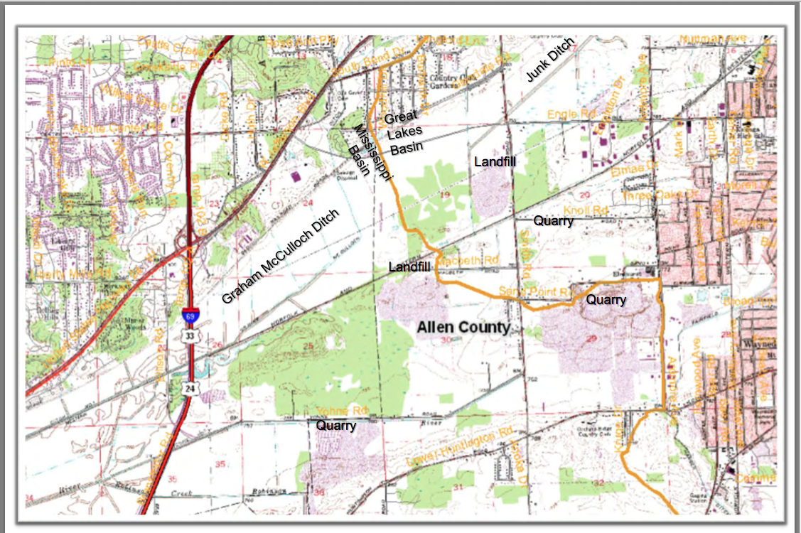
“Of primary concern are the Silver and Bighead carp which have been expanding their habitats within the Mississippi River basin for at least the past twenty years where they have decimated native fish populations by as much as 97 percent in some areas. These fish are currently threatening to enter the Great Lakes, a valuable fresh water resource.”   THIS is the specific location they are able to cross from the Mississippi via the Wabash to the Great Lakes via the St. Marys/Maumee.

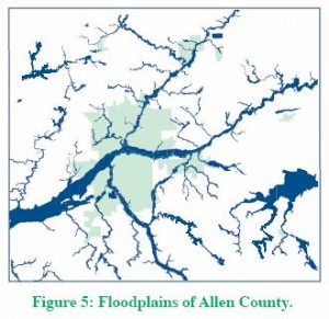
“Asian carp have been known to exist within the Wabash River for nearly 20 years. However, in May 2010 Indiana DNR observed Asian Carp eggs and spawning behavior much further upstream on the Wabash than was previously anticipated. The Wabash River was a “dead‐ end” for these fish as the Roush Dam prevents Asian carp from reaching the headwaters of the Wabash River. However, the Little River connects to the Wabash below the dam and its headwaters ebb into marshland on the southwestern edge of Fort Wayne, Indiana. Due to its proximity to the Maumee River system and recent flood events that have occurred within the floodplains between these two systems, there may be an opportunity for Asian carp to swim across the drainage divide at this location between the Great Lakes and the Mississippi River Basins. This is a critical concern because the Maumee River flows into Lake Erie, thus providing Asian carp with a potential for direct access to the Great Lakes.”

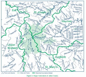
EXACT Lake Erie/Wabash Watershed Boundaries in Allen Countyhttp://www.asiancarp.us/documents/Wabash-Maumee-Field-Report_Final_small.pdf


Proposed Interim Measures:
   Inspect and increase/reinforce existing berm as necessary.
  Fencing from Graham McCulloch Ditch berm to railroad embankment
  Place mesh grates at the ends of underground conduits or cover the openings on both ends with large rock to allow water to flow through but impede fish passage.
Potential Long‐Term Measures:
  Potential for a physical separation measure with a water level control structure located within or to the west of Eagle Marsh.
  Potential fortification of Huntington Dam.


Save Maumee remains concerned about the lack of any plan, IF the Asian Carp DO make it into the Great Lakes.  We are unaware of any reports, hypotheses or theories; what is the educated guess, as to the plan, if the Asian Carp are IN Lake Erie?

Watershed Continental Divides in North America

October 10th, 2013

Watershed Continental Divides in North America

Purdue Publication RE: Allen County/Indiana Watersheds

September 13th, 2013


8 pages of solid information CLICK HERE:
Great Lakes Watershed / Allen County, Indiana

6 Watersheds in Allen Countymaumee map1


Put-In Bay – an all inclusive day on the Lake!

September 13th, 2013

Put-In-Bay

A Day on the Lake
September 20, 2013

2013 Bus trip Brochure

This is a very fun and educational bus trip to Put-in-Bay, where we will be treated to a tour of the newly-remodeled Ohio State University Water Quality Lab. After the tour we will then board the research vessels for an informative, hands-on cruise of Lake Erie. You will also have the opportunity to explore and enjoy lunch on the island.
This is an opportunity for Ag Retailers, Producers and concerned Citizens to learn about the ongoing research at OSU’s Stone Lab. These
programs & projects are helping to identify the causes of the harmful algal blooms and invasive species in Lake Erie. Phosphorus fertilizer is the limiting factor in the proliferation of the algae

$20 / person
Please send check to :
Allen SWCD
3718 New Vision Drive
Fort Wayne, IN 46845
Contact us:
260-484-5848 ext. 3
Or
Email us at Krista.Voors@IN.nacdnet.net

6:15 AM Board Bus at Meijer
10301 SR 37, Ft. Wayne,IN 46835
* Juice and rolls served *
6:30 AM Bus departs from Meijer
9:30 AM Depart Catawba Island via Miller Ferry to Put-In-Bay
5174 E. Water St., Port Clinton, OH 43452
10:00 AM Island Transport to Aquatic Visitor’s Center
* Snack served *
11:15 PM Science Cruise / Island Tour
12:30 PM Lunch
1:45 PM Science Cruise / IslandTour
3:30 PM Miller Ferry to Catawba
4:15 PM Bus departs from Catawba
6:30 PM Return to Meijer
(IN SR37 & I-469)
Lunch and morning
snack provided.
*Agenda is subject to change*


RiverFest at IPFW – Save Maumee Represented

July 5th, 2013

Presentation: June 22, 2013
  10:30AM – 11AM
Title: What can we do to make our 3 Rivers better; In-depth thought into surface water
Director, Abigail King said SMGO will release their new initiatives at RiverFest, that will “draw many eyes to the importance of water quality.”
“We plan to demonstrate the symbiotic relationship between stream health and how it is directly related to human health and recreation.”
By: Abigail King, Save Maumee Grassroots Organization Director & Founder

Secretary of Heartland Communities Inc. (Save Maumee’s nonprofit 501C3 fiscal sponsor)
Upper Maumee Watershed Partnership Treasurer
Maumee Valley Heritage Corridor; Region I Environmental Consultant
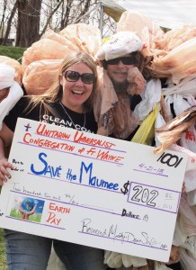
Abigail King and Bag Monster receive the collection plate from the UU!

Abigail King and Bag Monster receive the collection plate from the UU!

ACTIVE PRESENTATION FOR RIVERFEST ATTENDEES:

Save Maumee Grassroots Organization will be passing out native riverbank seed & chaff in salvaged reusable cotton-cloth bags at RiverFest.  SMGO wants these diverse and desirable contents to be planted on any local streambank.
Directions on the bag include, “if you want these seeds to grow, and work to improve water quality; only plant where nothing green grows, dirt is exposed, near an open water source, in an area that will NOT be mowed.  Then STOMP the seeds down flat with your shoes, flattening the open soil down, so it does not float away during the next rain.”
VICTORY for the RIVERS:
On 100% volunteer hours alone, Save Maumee has removed 26,728 lbs of rubbish from Fort Wayne’s Three Rivers. In place of the trash removed, the group planted over 2,000 trees and works to rehabilitate native species.  Since 2005, hundreds of volunteers have planted 900 lbs of seed and hundreds of pre-grown plants to slow erosion and sedimentation on riparian areas.  Strategies for erosion control through vegetation establishment has successfully promoted protection, raised awareness and inspired advocacy through educational hands-on projects.  To date, Save Maumee has been a 100% volunteer group that depends on the “kindness of strangers,” with donations and memberships from the public to support their work public events.
ACCOLADES:
  • 2008 through 2013, Save Maumee Grassroots Organization was chosen by Healing Our Waters to represent northeast Indiana for Clean Water Week in Washington, D.C., meeting with Federal Legislators.
  • 2011 Hoosier Environmental Council chose Save Maumee as “Indiana’s Organization of the Year”
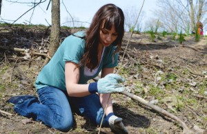
One of our hundreds of volunteers, planting along the Maumee River

One of our hundreds of volunteers, planting along the Maumee River

The group encourages active public participation by joining Save Maumee at Hall’s Gas House from 7-8:30pm, the First Monday of Every Month Meeting.

Next meeting is August 5th, 2013 – ALL WELCOME
—————————————————
What’s in the reusable bag? Native riverbank seed & chaff, meaning it is the protective casing from the seeds & attached stalks, which help to keep the soil loose as propagation begins. These seeds are from the region, and will grow into plants that are acclimated to local climates and soil types and wildlife are adapted to this native vegetation. We want these diverse and desirable contents to be planted on any local streambank in an area that will NOT be mowed.

Directions:
IF you want these seeds to work to improve water quality;
1) only plant where nothing green grows & dirt is exposed, near an open water source
2) Stir up the soil with a stick or shoe and gently work the mix into the ground
3) cover with less than 1/4th inch soil
4) press down with your shoe to keep it in the ground.
ENJOY!~

Notice the prices reflect value of our natural resources, and they are going up because they are not getting any easier to find!
Hundreds of volunteers plant hundreds of "plant plugs" and trees!

Hundreds of volunteers plant hundreds of “plant plugs” and trees!

DIVERSITY is very important. COST TO PURCHASE (based on 2013 prices)
Prairie Drop Seed $15/oz or $225/LB
Common Milkweed $11/oz or $170/LB
Tall Iron Weed $18/oz or $265/LB
Wild Bergamot/Monarda $20/oz or $304/LB
Evening Primrose $5/oz
Acorns that grow into Oak Trees $7/LB

________________________________


Water quality suffers without enforcement of the laws created to protect public health

April 14th, 2013

“Critics have long complained that IDEM is understaffed, underfunded and doesn’t do enough to protect the environment.”  IDEM, is an “18-year-old state agency with a $161 million budget and more than 900 employees. (Associated Press, ‘Activists wonder where Daniels will lead state’s environment’ Nov. 22, 2004).

_______________________________________________________

“The state issued more than $2 million in environmental fines in northeast Indiana from 2004 through 2006, but not all the money was actually collected.

Indiana Department of Environmental Management records showed fines in northeast Indiana ranging from $300 to $382,725 during that period, according to The Journal Gazette review of the data published [December 2007] (Indy Star, “IDEM fails to collect fines in full” Dec. 10, 2007).
_______________________________________________________

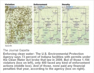
Now the latest report on Violations, Enforcement & Penalties:
http://www.journalgazette.net/article/20120819/LOCAL10/308199948

Clean Water Act violations rising, seldom punished;
State regulators dispute findings from EPA data

Journal Gazette   –     Dan Stockman    –   20 August 2012

Nearly three out of every four facilities in Indiana operating under the
Clean Water Act broke that law in 2009, EPA data show, but of all those
violators, only one-third faced any kind of sanctions.

2012 Indiana Violations & Enforcement –


IPFW Environmental Conservation Class-Field work with Save Maumee

April 14th, 2013

Dr. Jordan Marshall – IPFW Environmental Conservation Class
Monday October 15, 2012 1:30– 2:30pm
Location: St. Joseph and St. Marys converge into the headwaters of the Maumee River – .7 miles downstream easterly
Hosey Dam (at N. Anthony Bridge) North bank of the Maumee River; (floodway/spillway- direct middle) sand, loam, clay, river sediment
NUMBER OF VOLUNTEER PARTICIPANTS – 24

Save Maumee Programing
Project with IPFW Environmental Conservation Class
In-kind student volunteers completed restoration project
CLICK HERE FOR PICTURES
In the floodway we planted 4 Pin Oak, 2 Mulberry, 2 River Birch, and one Hornbeam and 30 Oak Acorns into the stretch of river where Save Maumee conducts the majority of conservation projects.  As a group today, we also planted native DNR approved seeds; Big Blue Stem, Indian Grass, Switchgrass, New England Aster, Grass Leaved Goldenrod, Prairie Dock, Virginia Mountain Mint, Ironweed, Purple Coneflower, Monarda, and Black Eyed Susan and a few unidentified sedges.  We installed the seed blend under 19 feet of coconut mesh, called erosion-control-mats or GeoJute.  GeoJute is made from coconut fiber that will completely disintegrate in approximately 5 years. The coconut mesh is to hold down new life as the water raises and flows over the floodway.

Dr. Marshall brought it to my attention that several of the species I had mentioned may not do well under the tree canopy and prefer upland areas.  SO TRUE!  Different plants prefer different conditions.  The top of that seed bag, I had harvested myself, had a blend of seed.  With the experiment I have started in this area, I have found that not-ideal conditions still yield life! It just seems to stunt their growth, slowing their full potential for abundance.   For example, the Prairie Dock should be “full sun”, but they still were prolific this year!  These Prairie Dock were located on the high water mark, yet tree canopy covered.  Black Eyed Susan has been suggested by our consultant, Eric Ummel, from Earth Source/Heartland Restoration.  Black Eyed Susan has been extremely successful as shade tolerant in our efforts.

According to William Grant, retired Lagrange County Health Department Administrator, whom I personally interviewed in 2007. 

Wet Mesic Prairie Plants” are the suggested foliage for this area. “Wet Mesic Prairie Plants are a blend of plants that reduce nutrients and nitrates…ya know…these plants drink the stuff from leaking septic tanks, or dirty ditches.

Dr. Marshall and I could split hairs, because many of these (above listed) plants are lowland grasses that like it moist and prefer soils primarily loam or silt.  But I am still agreeing with Dr. Marshall, and appreciate his critique!  YES, some are not “suitable” for this area.

Remember: Not all the plants will grow specifically where we dropped them.  When the river rises, many will become dislodged and find different conditions downstream to germinate.  Planting seed does not happen in a vacuum, it is static.

Lesson Learned for Myself: When I asked Dr. Marshall about his thoughts on listening to me speak on two different occasions recently: 1) IPFW Anthropology Dept. Lunch-In   2) Environmental Conservation Class. He gave me some great feedback that I needed to hear.  We spoke of my reference to removing NATIVE wild grape vines.  The good Dr. said, “this is only a snapshot of the biology of this area…it is part of the process that nature is creating. You should think seriously about the promotion of removing natives…where did you hear that?”  So I wanted to clarify my thoughts on wild grape vine.

My erosion control projects started in 2005 and my research on our local rivers began in 2001.  I think I misspoke, or was not clear, about Vitis riparia.  This particular grape vine is prolific on my specific experimental floodway area on the north shore.  I have selectively chosen ones that are choking-out other trees and working to achieve and promote diversity of other species through selective removal of V. riparia.

Other State and County Park representatives discuss how they have invasive like Callery flowering Pear tree, Garlic Mustard, or Polk (Phytolacca Americana is native to southeastern U.S.)   Our riverbank does not have an over abundance of these because we remove them by hand, on sight.  We do not promote removing riverbank plants or using chemicals, of any kind, 300ft from the open water source.

Save Maumee is suggesting that every Japanese Honeysuckle (non-natives are hollow in the middle) you see should be removed.  The Japanese Honeysuckle has been shown to give local bird populations’ problems. Non-native berries do not provide the nutrients and minerals needed.  Birds will therefore spend more time foraging for more food because they are lacking nutrition.  This means they are not spending their precious time seeking a mate, nesting, nor tending to young.

These days many of the protected lands are managed.  They have a conservation target that is created through a management plan.  Many times the managed lands remove natives, like Cattails, because they smother other natives and discourage diversity around wet, stagnant water.  This too is important to note! Thank you Dr. Marshall! This brings up the point that my management plan has been in my head and I need to create one for my Lake Erie Waterkeeper, Save Maumee Steering Committee.

My conservation target from my head:
GOAL: SWIMMABLE, FISHABLE, DRINKABLE WATER
*raise awareness
*plant diverse native species:  slow erosion by slowing flood water as it violently runs over the floodway
to water takes a longer amount of time to naturally filtrate into the ground
*create this biodiversity through removing threats to the conservation target (i.e. removing invasives or overgrowth.

I will quote SaveMaumee.Org Website:

      Siltation/erosion/sedimentation is the #1 pollutant in our watershed.  The grasses will help to settle out suspended sediment in the water to help hold down the soil that could be washed away because there is nothing to hold down the barren soil when the water comes rushing down during a rain event.

      Grasses filtrate sediment by holding water for a longer period of time so the sediment settles to the bottom instead of traveling downstream.

      Removal of nutrients from the water before it passes downstream.

      Plants produce enzymes which will absorb and “eat” bacteria

      Natural removal of chemical pollutants like fertilizers and waste materials removes nitrogen, phosphorous and toxins from surface water.

      Creating more shade will help to create Dissolved Oxygen that is needed in the water for fish and other wildlife to “breathe.”

      Floods problems can be alleviated – grassy knolls and trees can capture, store and slowly release water over a longer period of time

      Protect shorelines through reduction of destructive energy from fast moving/ rising water

      Alleviate pools of standing, stagnant water so West Nile will not have the opportunity to be passed on in the mosquito or human population

Water quality, stormwater drainage and sewage issues recognize no political boundaries and need regional coordination.” (Plan-It-Allen, 2007)
The Upper – Maumee River Crosses 2 State Boundaries 4 County Boundaries Numerous Municipalities

Most people who live in cities downstream of Fort Wayne, use The Maumee River as their drinking water source.  Other drinking water sources would include wells.

Dear Dr. Marshall, I respect and took into consideration all of your suggestions, thank you.  Bringing students back into the field, instead of behind pencils, 3 miles away, is invaluable!  THANK YOU TOO STUDENTS! ALL our work to this point has been through the kindness of volunteers.  Please continue to keep an eye on us. We would love to have you at one of our meetings.  We would look forward to many of your perspectives!  Save Maumee Meetings are OPEN TO THE PUBLIC every 1st Monday of every month at Hall’s Gas House from 7-8:30pm.  Please feel free to comment on anything, because I truly value your opinion and your students’ opinions!

Today, October 28, 2012 – We are working to find out more about the removal of our plantings via City of Fort Wayne, Board of Public Works (BPW)from orders passed down to the Army Corps of Engineers (ACE).

On Wednesday, October 24 we witnessed all foliage cut and any tree under three-inches in diameter being removed, in our conservation target area.  We are now seeking the correspondence between the ACE and BPW regarding this sensitive situation.  I will keep you informed.  Makes me think now the grape vines were more important than I thought!
Celia Garza, Board Secretary

April 14th, 2013

Where are all the trees? ~ It’s not JUST the Emerald ash borer destroying natural habitat.

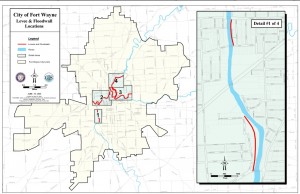
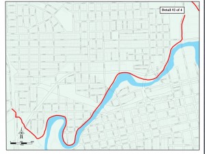
The Army Corp of Engineers follows the “Guidelines for landscape planting and vegetation management at levees, floodwalls, embankment dams and appurtenant structures (ETL 1110-2-571)” when deciding what trees and plants to remove [on levees]. Downtown Fort Wayne has 8 miles of “downtown river front development” and 10.5 miles of levees next to our rivers. If you have any questions or are concerned with the removal of our natural resources, trees and plants, please contact the following City of Fort Wayne and other government employees:

image (2)image image (3)  image (4)

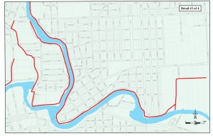
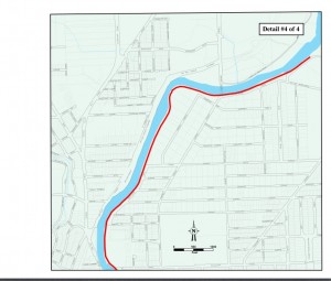
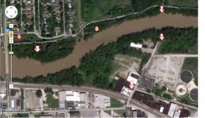
FORT WAYNE, INDIANA ARMY CORPS OF ENGINEER LEVEES (Detroit District) – CLICK MAP TO ENLARGE
10.5 miles are maintained by a non-federal agency/municipality = City of Fort Wayne Board of Public Works

#1   Tina Kowitz, P.E
Levee Safety Program Manager
Geotech & Structures Branch
U.S. Army Corps of Engineers, Detroit District
ph: (313) 226-6719
cell: (313) 244-6283

#2   Board of Public Works
Bob Kennedy – Manager (260) 427-2693
Shan Gunawardena – Engineer (260) 427-1172
City of Fort Wayne
Citizens Square Bldg. 2nd Floor
(260) 427-1112

#3  Federal Senator Dan Coats
Legislative Assistants:
Paige Hallen
Casey Murphy
Kate Taylor
493 Russell Office Bldg
Washington, DC, 20510
ph: (202) 224-5623

#4  Federal Senator Joe Donnelly
Legislative Assistant: Audrey Porter
SR-B33 Russell Senate Office Building
Washington, DC 20510
ph: (202) 224-4814

Thank you for calling,

Celia Garza
Save Maumee Grassroots Organization
Board of Trustees Secretary


HAPPENINGS!

April 6th, 2013
Save Maumee Grassroots Office  800 Glasgow Ave.  Fort Wayne, IN 46803 2nd Floor

Save Maumee Grassroots Office
800 Glasgow Ave.
Fort Wayne, IN 46803
2nd Floor


2013 Earth Day Flier

EARTH DAY is Sunday April 21st from 11am-4pm

Map here for all the FUN on Earth Day!

 START AT STATION 1

Our social media outreach and updates have been sparse since my loving father AND our webguy, Brad Frost is very ill with cancer.

FIND ALL THE INFO ABOUT EARTH DAY HERE!

For more updates on a regular basis….check out our FACEBOOK!

Call if you need anything or would like to participate!
Abby 260.417.2500
EMAIL: Abby@SaveMaumee.Org

Steering Committee Chair Discusses Levee Maintenance

January 17th, 2013

Save Maumee wants to talk openly with city officials, and with the taxpayers, about our waterways and the cause & effect of current practices relating to land use and water quality. The water we speak of is the same water we drink, bathe our children in, water our gardens with, and live alongside. It is our greatest natural resource.

Recently, the city hired a tree service to remove vegetation along the Niagara Levee (the same area Save Maumee has been repairing since 2005) for a levee inspection in December 2012. Conversations with Flood Control Supervisor Cathy Burleson revealed that the Army Corps of Engineers required much of this removal in their levee regulations that came as a result of Hurricane Katrina. She stated that she did not want to cut the trees down, ACE regulations required her to do so. Burleson also mentioned that there are 10.5 miles of levees that the City of Fort Wayne, Board of Public Works, are responsible for maintaining. Walk the River Greenway along Edgewater Avenue or Spy Run and you can see that definition of maintenance ~ removal of all trees and vegetation with the installation of rip rap. One small portion of Edgewater was developed using what was referred to as “green” technique (using vegetation surrounded by non-degradable, plastic mesh called Scour Stop at a large additional cost).

We understand the issue of levee safety in those areas are a priority, and are in complete agreement that the safety of the home and business owners, and their property are of utmost importance.  The last thing that we want is for anyone’s lives or homes to be in danger as a result of any compromising of the structure of the levees.

The problem that we seem to be having in Fort Wayne is the primary solution to control flooding is being addressed through removal of native plants and trees for “integrety of levee structures”.  It has been well documented in a vast amount of literature and studies (even those reported by the Corps, the EPA, and FEMA) that issues such as increased impervious surfaces, the use of rip rap, removal of vegetation, and removal of wetlands not only increase the likelihood that flooding will occur during peak seasons, but also that water quality will (and does) continue to decrease due to the removal of such areas.  Not to mention the effects on habitats and wildlife, both serving critical links in the food chain for humans and other wildlife.
Edgewater DURING removal of vegetation 2011

We have been observing the Board of Works cutting down “weeds” and “trees” along the levees because of the regulations that require them to do so, handed down by the Corps, in an effort to protect homeowners from flood waters.  We don’t see the Board of Works planting Willow shrubs in the allowable portions of the riparian areas or planting native grasses to assist in keeping the soil on the banks from eroding (as recommended by the Corps).  We only see them taking away from riverbank areas~and replacing trees, grasses, and shrubs with more impervious surfaces in floodways.  We don’t see the Fort Wayne Parks Department or City Planning making any concerted effort to decrease the likelihood of flooding by preserving natural areas with appropriate vegetation plantings to contain flood water (as a wetland would do).  Instead we see variances for housing additions, gas stations, strip malls, and pavement ~ all contributing to both flooding and decreasing water quality.

Edgewater levee AFTER vegetation removal & installation of Scour-Stop

The practices that are being used by our local government are antiquated procedures that are increasing the likelihood that our waterways will spill over during peak seasons.  We are urging the Corps and our city government to make more responsible choices when it comes to the overall picture, for Fort Wayne and for those downstream.  The Upper Maumee Watershed Partnership and the Army Corps of Engineers recognized in a 2009 report that the city of Fort Wayne’s Flood Control “projects are localized and do not address overall problems.”  It was recommended in this same report that riparian areas be expanded, and that the increase use of USDA/NRCS practices of restoring wetlands would help to decrease peak discharges into the waterways.  The city has made little effort to do either, instead relying on non-profit groups to do the work for them.

The riparian area that Save Maumee has worked on since 2005 is the only area of the Fort Wayne rivers where a riparian area is actively being re-established, thanks to over 300 volunteers who come out each Earth Day to repair that one small portion of the Maumee River ~ the Maumee is the largest watershed that flows into the Great Lakes.  Up to 80% of a stream’s water quality is inherited at its headwaters (Hoosier Riverwatch 2009); for the Maumee River, that is in Fort Wayne, Indiana.  Both the St. Marys and the St. Joseph Rivers (which come together to form the Maumee River)  are on the  2010 303(d) List of Impaired Waterways due to E. coli.  Other impairments that plague the rivers and watershed are Mercury, Nutrients, Free Cyanide, PCB’s, Siltation, and Ammonia ~ pollutants that impair the Maumee River from Fort Wayne to Lake Erie.

The installation of rip rap and removal of vegetation has been common practice along eroding areas of our rivers, increasing the speed of the water through the rivers after running off of impervious surfaces, thereby increasing the likelihood of soil erosion downstream from these areas and also the likelihood of flooding downstream as well. The city and county continuously allows the clearing of natural areas for development, areas that could be utilized to slow down water and hold it for storage until it has a chance to percolate through the soil via the root systems of native plants and recharge the groundwater supplies ~ which would also filter the water while decreasing soil erosion on the banks downstream.   The practices that are being utilized are actually increasing the problems and increasing the burden on taxpayers and homeowners.  We want to see our city and the Corps work to decrease the chances of flooding, while simultaneously decreasing that financial burden.

We understand that the position of the Corps is to maintain safe and secure levees, not to be involved in the local government issues.  The problem is that all of these water issues are connected and it does not appear as if there has been much effort from any of the decision makers to promote less invasive and more efficient and practical methods of dealing with flooding or water quality.  We are asking that the all involved decision makers begin to work toward more fiscally and ecologically responsible solutions on these issues.

Marissa Jones

Lake Erie Waterkeeper,
Save Maumee Steering Committee Chair
Marissa@SaveMaumee.Org

Cited Work:
Effects of Rip Rap on Riverine and Riparian Ecosystems.” Army Corps of Engineers Report, April 2003.

“Functions and Values of Wetlands.” Environmental Protection Agency, September 1, 2001. http://water.epa.gov/type/wetlands/outreach/upload/fun_val_pr.pdf

Engineering With Nature; Alternative Techniques to Riprap Bank Stabilization.” FEMA Report, modified January 2011.

“Landscape Planting: Objectives and Engineering Requirements.” Chapter 2. Army Corps of Engineers ETL 1110-2-571, 10 April 2009.

“Western Lake Erie Basin Study, Upper Maumee Watershed Assessment.” Western Lake Erie Basin Partnership, 3 August 2009.