Archive for the ‘Map’ Category

MAP: Specific differentiation between Mississippi Basin & Great Lakes Basin

Thursday, October 10th, 2013

From the document:
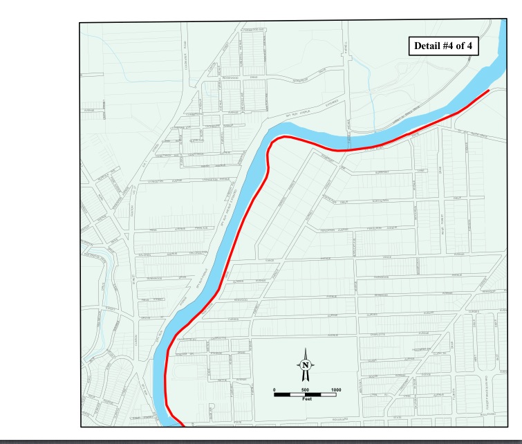
Wabash – Maumee Connection

Site Visit Field Report

July 27, 2010 

Prepared For:
U.S. Environmental Protection Agency Great Lakes National Program Office 

http://www.asiancarp.us/documents/Wabash-Maumee-Field-Report_Final_small.pdf

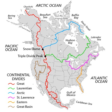
“Of primary concern are the Silver and Bighead carp which have been expanding their habitats within the Mississippi River basin for at least the past twenty years where they have decimated native fish populations by as much as 97 percent in some areas. These fish are currently threatening to enter the Great Lakes, a valuable fresh water resource.”   THIS is the specific location they are able to cross from the Mississippi via the Wabash to the Great Lakes via the St. Marys/Maumee.

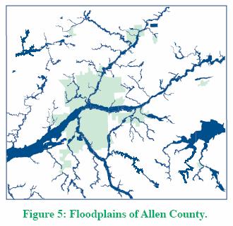
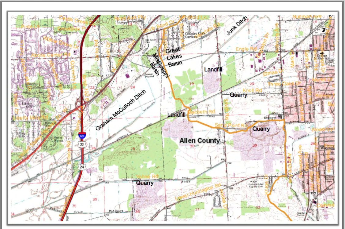
“Asian carp have been known to exist within the Wabash River for nearly 20 years. However, in May 2010 Indiana DNR observed Asian Carp eggs and spawning behavior much further upstream on the Wabash than was previously anticipated. The Wabash River was a “dead‐ end” for these fish as the Roush Dam prevents Asian carp from reaching the headwaters of the Wabash River. However, the Little River connects to the Wabash below the dam and its headwaters ebb into marshland on the southwestern edge of Fort Wayne, Indiana. Due to its proximity to the Maumee River system and recent flood events that have occurred within the floodplains between these two systems, there may be an opportunity for Asian carp to swim across the drainage divide at this location between the Great Lakes and the Mississippi River Basins. This is a critical concern because the Maumee River flows into Lake Erie, thus providing Asian carp with a potential for direct access to the Great Lakes.”

EXACT Lake Erie/Wabash Watershed Boundaries in Allen Countyhttp://www.asiancarp.us/documents/Wabash-Maumee-Field-Report_Final_small.pdf


Proposed Interim Measures:
   Inspect and increase/reinforce existing berm as necessary.
  Fencing from Graham McCulloch Ditch berm to railroad embankment
  Place mesh grates at the ends of underground conduits or cover the openings on both ends with large rock to allow water to flow through but impede fish passage.
Potential Long‐Term Measures:
  Potential for a physical separation measure with a water level control structure located within or to the west of Eagle Marsh.
  Potential fortification of Huntington Dam.


Save Maumee remains concerned about the lack of any plan, IF the Asian Carp DO make it into the Great Lakes.  We are unaware of any reports, hypotheses or theories; what is the educated guess, as to the plan, if the Asian Carp are IN Lake Erie?

Watershed Continental Divides in North America

Thursday, October 10th, 2013

Watershed Continental Divides in North America

Purdue Publication RE: Allen County/Indiana Watersheds

Friday, September 13th, 2013


8 pages of solid information CLICK HERE:
Great Lakes Watershed / Allen County, Indiana

6 Watersheds in Allen Countymaumee map1


Celia Garza, Board Secretary

Sunday, April 14th, 2013

Where are all the trees? ~ It’s not JUST the Emerald ash borer destroying natural habitat.

The Army Corp of Engineers follows the “Guidelines for landscape planting and vegetation management at levees, floodwalls, embankment dams and appurtenant structures (ETL 1110-2-571)” when deciding what trees and plants to remove [on levees]. Downtown Fort Wayne has 8 miles of “downtown river front development” and 10.5 miles of levees next to our rivers. If you have any questions or are concerned with the removal of our natural resources, trees and plants, please contact the following City of Fort Wayne and other government employees:

image (2)image image (3)  image (4)

FORT WAYNE, INDIANA ARMY CORPS OF ENGINEER LEVEES (Detroit District) – CLICK MAP TO ENLARGE
10.5 miles are maintained by a non-federal agency/municipality = City of Fort Wayne Board of Public Works

#1   Tina Kowitz, P.E
Levee Safety Program Manager
Geotech & Structures Branch
U.S. Army Corps of Engineers, Detroit District
ph: (313) 226-6719
cell: (313) 244-6283

#2   Board of Public Works
Bob Kennedy – Manager (260) 427-2693
Shan Gunawardena – Engineer (260) 427-1172
City of Fort Wayne
Citizens Square Bldg. 2nd Floor
(260) 427-1112

#3  Federal Senator Dan Coats
Legislative Assistants:
Paige Hallen
Casey Murphy
Kate Taylor
493 Russell Office Bldg
Washington, DC, 20510
ph: (202) 224-5623

#4  Federal Senator Joe Donnelly
Legislative Assistant: Audrey Porter
SR-B33 Russell Senate Office Building
Washington, DC 20510
ph: (202) 224-4814

Thank you for calling,

Celia Garza
Save Maumee Grassroots Organization
Board of Trustees Secretary


HAPPENINGS!

Saturday, April 6th, 2013
Save Maumee Grassroots Office  800 Glasgow Ave.  Fort Wayne, IN 46803 2nd Floor

Save Maumee Grassroots Office
800 Glasgow Ave.
Fort Wayne, IN 46803
2nd Floor


2013 Earth Day Flier

EARTH DAY is Sunday April 21st from 11am-4pm

Map here for all the FUN on Earth Day!

 START AT STATION 1

Our social media outreach and updates have been sparse since my loving father AND our webguy, Brad Frost is very ill with cancer.

FIND ALL THE INFO ABOUT EARTH DAY HERE!

For more updates on a regular basis….check out our FACEBOOK!

Call if you need anything or would like to participate!
Abby 260.417.2500
EMAIL: Abby@SaveMaumee.Org

NASA~Earth Observatory over past 130 years

Monday, December 20th, 2010

http://earthobservatory.nasa.gov/Features/WorldOfChange/decadaltemp.php?src=eoa-features

A snapshot of Earth over the past 130 years with heating and warming trends.

“A one-degree global change is significant because it takes a vast amount of heat to warm all the oceans, atmosphere, and land by that much. In the past, a one- to two-degree drop was all it took to plunge the Earth into the Little Ice Age. A five-degree drop was enough to bury a large part of North America under a towering mass of ice 20,000 years ago. ”

Please take care of Her!

Sierra Club – EPA Waste Site Map

Saturday, February 27th, 2010

http://maps.google.com/maps/ms?ie=UTF8&hl=en&t=h&msa=0&msid=106949531795848980635.00047a1bfebc809599725&ll=39.300299,-90.791016&spn=23.74567,56.25&z=4&source=embed

Google Map created by Sierra Club from EPA – Includes sites, hazardous sites and spill sites!

Is there one near you?